Search Results
948 results found with an empty search
- Honeyscent Navarretia Navarretia mellita
Wildflower Mount Diablo Honeyscent Navarretia Scientific Name: Navarretia mellita Family: Polemoniaceae (Phlox Familiy) Blooms: Jun Color: Blue-Purple Annual herb Native, endemic to California Jump to Blooming Now Blue / Purple Red / Pink White Yellow / Orange Invasive Plants David Greenberger, iNaturalist
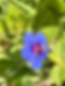
- Chaparral Harebell Ravenella exigua
Wildflower Mount Diablo Chaparral Harebell Scientific Name: Ravenella exigua Family: Campanulaceae (Bell flower Family) Blooms: May - Jun Color: Blue-Purple Annual herb Native, endemic to California This plants is rare in Mount Diblo State Park. See full list Jump to Blooming Now Blue / Purple Red / Pink White Yellow / Orange Invasive Plants Mike Woodring
- Chaparral Broomrape, Tuberous Broomrape Aphyllon tuberosum
Wildflower Mount Diablo Chaparral Broomrape, Tuberous Broomrape Scientific Name: Aphyllon tuberosum Family: Orobanchaceae (Broomrape Family) Blooms: Mar - Jun Color: Blue-Purple Perennial herb (parasitic) Native, endemic to California Jump to Blooming Now Blue / Purple Red / Pink White Yellow / Orange Invasive Plants Stephen Smith Mike Woodring
- American Vetch Vicia americana
Wildflower Mount Diablo American Vetch Scientific Name: Vicia americana Family: Fabaceae (Legume Family) Blooms: May-Jun Color: Blue-Purple Perennial herb or vine Native Jump to Blooming Now Blue / Purple Red / Pink White Yellow / Orange Invasive Plants Steve Beatty
- Blue Scarlet Pimpernel Lysimachia loeflingii
Wildflower Mount Diablo Blue Scarlet Pimpernel Scientific Name: Lysimachia loeflingii Family: Myrsinaceae (Primulaceae) Blooms: Mar-Sep Color: Blue-Purple Annual herb Introduced Jump to Blooming Now Blue / Purple Red / Pink White Yellow / Orange Invasive Plants Steve Smith
- Harvest Brodiaea Brodiaea elegans ssp. elegans
Wildflower Mount Diablo Harvest Brodiaea Scientific Name: Brodiaea elegans ssp. elegans Family: Themidaceae (Brodiaea Family) Blooms: May - Jun Color: Blue-Purple Perennial herb Native Jump to Blooming Now Blue / Purple Red / Pink White Yellow / Orange Invasive Plants Mike Woodring
- Artichoke Thistle Cynara cardunculus
Wildflower Mount Diablo Artichoke Thistle Invasive Scientific Name: Cynara cardunculus Family: Asteraceae (Sunflower Family) Blooms: June Color: Blue-Purple Perennial herb Introduced Jump to Blooming Now Blue / Purple Red / Pink White Yellow / Orange Invasive Plants Steven Beatty
- Birds-1
Birds A-Z 1 2 3 4 5 1 ... 1 2 3 4 5 ... 5 Acorn Woodpecker Melanerpes formicivorus Allen's Hummingbird Selasphorus sasin American Crow Corvus brachyrhynchos American Kestrel Falco sparverius American Pipit Anthus rubescens American Robin Turdus migratorius Anna's Hummingbird Calypte anna Ash-throated Flycatcher Myiarchus cinerascens Band-tailed Pigeon Patagioenas fasciata Barn Owl Tyto alba Barn Swallow Hirundo rustica Bell's Sparrow Artemisiospiza belli Bewick's Wren Thryomanes bewickii Black Phoebe Sayornis nigricans Black-headed Grosbeak Pheucticus melanocephalus Black-throated Gray Warbler Setophaga nigrescens Blue-Gray Gnatcatcher Polioptila caerulea Brewer's Blackbird Euphagus cyanocephalus Brown Creeper Certhia americana Brown-headed Cowbird Molothrus ater Bullok's Oriole Icterus bullockii Burrowing Owl Athene cunicularia Bushtit Psaltriparus minimus California Quail Callipepla californica California Scrub Jay Aphelocoma californica 1 2 3 4 5 1 ... 1 2 3 4 5 ... 5
- Bees (List) | mdia
Bees A-Z Filter by Bee Type Select Bee Type Andrena Miner Bee Andrena January - Fall (but primarily January - April) Read More Ashmeadiella Ashmeadiella Summer Read More Bindweed Turret Bee Diadasia bituberculata April to June Read More Black-tailed Bumble Bee Bombus melanopygus January - July (rarely as early as December) Read More California Bumble Bee Bombus californicus February - September Read More California Digger Bee Anthophora californicus February - May; there may be a Fall generation too Read More California Digger-cuckoo Bee Brachymelecta californica June - August Read More California Fairy Bee Perdita californica April - June, timed to blooming of Mariposa Lily Read More California Mountain Digger Bee Habropoda depressa February - early June Read More California Poppy Fairy Bee Perdita interrupta April - June, timed to blooming of California Poppy Read More California Resin-Leafcutter Bee Trachusa perdita April - June Read More California Rotund-Resin Bee Anthidiellum notatum robertsonii May - August Read More Chelostoma californicum Scissor Bee Chelostoma californicum April - June Read More Colletes Cellophane Bees Colletes March - Fall Read More Dark Bees Stelis April - June Read More Dianthidium Dianthidium Late May - August Read More Edwards Digger Bee Anthophora edwardsii Earlier Spring (starting late-February/early March) Read More Edwards Melectum Melecta edwardsii March - early June Read More Eucera Longhorn Bee Eucera March to June Read More Foothill Carpenter Bee Xylocopa tabaniformis orpifex Later March - June Read More Hoplitis Mason Bee Hoplitis April - early June. Read More Hylaeus Masked Bees Hylaeus April - September Read More Lasioglossum Lasioglossum Early Spring – Fall Read More Lovely-tailed Mourning Bee Melecta separata callura March - May Read More Megachile Leafcutter Bee Megachile Summer Read More Melissodes Longhorn Bee Melissodes Late Summer to Fall Read More Nomad Bees Nomada February - June Read More Osmia Mason Bee Osmia Primarily April - June, but Osmia ribifloris biedermannii appears from January. Read More Pacific Digger Bee Anthophora pacifica February and March - not common. Read More Panurginus Miner Bee Panurginus Early Spring Read More Prong-faced Slender-Mason Bee Protosmia rubifloris April - August Read More Red-tailed Micro-Shortface Bee Micralictoides ruficaudus April and May Read More Small Carpenter Bee Ceratina March - July Read More Tripartite Sweat Bee Halictus tripartitus March - November Read More Urbane Digger Bee Anthophora urbana Late Spring - Early Fall Read More Valley Carpenter Bee Xylocopa sonorina March – September (Uncommon on Mount Diablo) Read More Yellow-faced Bumble Bee Bombus vosnesenskii January - September Read More
- Bees-Halictidae (List) | mdia
Sweat Bees Lasioglossum Lasioglossum Early Spring – Fall Read More Red-tailed Micro-Shortface Bee Micralictoides ruficaudus April and May Read More Tripartite Sweat Bee Halictus tripartitus March - November Read More
- Bees-Andrenidae (List) | mdia
Fairy and Miner Bees California Fairy Bee Perdita californica April - June, timed to blooming of Mariposa Lily Read More California Poppy Fairy Bee Perdita interrupta April - June, timed to blooming of California Poppy Read More Andrena Miner Bee Andrena January - Fall (but primarily January - April) Read More Panurginus Miner Bee Panurginus Early Spring Read More
- Bees-Apidae (List) | mdia
Diggers, Bumbles, Longhorn, and Nomad Bees Black-tailed Bumble Bee Bombus melanopygus January - July (rarely as early as December) Read More California Bumble Bee Bombus californicus February - September Read More Yellow-faced Bumble Bee Bombus vosnesenskii January - September Read More Foothill Carpenter Bee Xylocopa tabaniformis orpifex Later March - June Read More Small Carpenter Bee Ceratina March - July Read More Valley Carpenter Bee Xylocopa sonorina March – September (Uncommon on Mount Diablo) Read More California Digger-cuckoo Bee Brachymelecta californica June - August Read More Edwards Melectum Melecta edwardsii March - early June Read More Lovely-tailed Mourning Bee Melecta separata callura March - May Read More Nomad Bees Nomada February - June Read More California Digger Bee Anthophora californicus February - May; there may be a Fall generation too Read More California Mountain Digger Bee Habropoda depressa February - early June Read More Edwards Digger Bee Anthophora edwardsii Earlier Spring (starting late-February/early March) Read More Pacific Digger Bee Anthophora pacifica February and March - not common. Read More Urbane Digger Bee Anthophora urbana Late Spring - Early Fall Read More Eucera Longhorn Bee Eucera March to June Read More Melissodes Longhorn Bee Melissodes Late Summer to Fall Read More Bindweed Turret Bee Diadasia bituberculata April to June Read More