Search Results
924 results found with an empty search
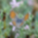
- Western Pygmy-Blue
Western Pygmy-Blue Brephidium exilis exilis Lycaenidae Blues, Coppers, Hairstreaks Flies June to November Host Plant Pigweed Nectar Plant Alice Castellanos Bob Hislop Daniel Fitzgerald Underwing
- Golden-carpet Buckwheat, Wicker Buckwheat Eriogonum luteolum luteolum
Wildflower Mount Diablo Golden-carpet Buckwheat, Wicker Buckwheat Scientific Name: Eriogonum luteolum luteolum Family: Polygonaceae (Buckwheat Family) Blooms: Jul-Sep Color: White Annual herb Native, and endemic to California Jump to Blooming Now Blue / Purple Red / Pink White Yellow / Orange Invasive Plants Daniel Fitzgerald Daniel Fitzgerald Daniel Fitzgerald Daniel Fitzgerald
- Western Meadowlark
Western Meadowlark Blackbirds, Orioles, and Meadowlarks Western Meadowlark Sturnella neglecta All Year Blackbirds, Orioles, and Meadowlarks Daniel Fitzgerald Drab, mottled brown back color contrasts with yellow breast and V-shaped black band on the underparts. In flight, note the white outer tail feathers. Song is distinctly flute-like. Nests on the ground. Grasses and plant-stems are used to build a cup-shaped nest that is often domed. Feeds on seeds and insects.
- Hairy Bird’s Beak Cordylanthus pilosus ssp. pilosus
Wildflower Mount Diablo Hairy Bird’s Beak Scientific Name: Cordylanthus pilosus ssp. pilosus Family: Orobanchaceae (Broomrape Family) Blooms: July Color: White Annual herb Native, endemic to California Jump to Blooming Now Blue / Purple Red / Pink White Yellow / Orange Invasive Plants Steven Beatty
- Painted Lady
Painted Lady Vanessa cardui Nymphalidae Brushfoots Flies All year Host Plant Thistle, Lupine, many more Nectar Plant Italian thistle Daniel Fitzgerald Male Michael Woodring Underwing
- Mountain Lions
Mountain Lions by Michael Sewell Mount Diablo State Park January 1, 1999 The animal population I am most frequently asked about is that of the mountain lion, also called the puma or cougar. There are twenty-seven different subspecies. The local variety is one of the largest subspecies, but it has become extinct in may of the areas where it once thrived. It would not be entirely accurate to say that there is a mountain lion population on Mount Diablo. Lions have been known to range over 20 miles in one night. They use Mount Diablo as part of their range. No other animal presents a stronger case for the importance of wildlife corridors, such as the one connecting Mount Diablo with Morgan Territory park, and with Black Diamond Mines Regional Park. Over the years, there have been many mountain lion sightings. Here's a glimpse of a few recent ones: a very large, dark-colored mountain lion was seen on Mount Diablo in the Pine Canyon area; a mountain lion and cub tracks appeared around my photography blind while I slept one night in 1989 on Mount Diablo, and; a mountain lion and cub (I believe the same pair) were spotted a few weeks later near Danville. Still another sighting of an adolescent occurred on the road near Juniper campground in 1990. All three of these young lion sightings were probably the same lion. I also got a fleeting glimpse of an adult last year in the Morgan Territory area. Based on these sightings and others, I believe a handful of mountain lions use Mount Diablo as part of their range. While it may be true that Mount Diablo is the most important part of their range, without corridors to other protected lands, they will probably not survive in the area. Download Common Mammal Tracks of Mount Diablo (pdf) BACK TO LIST
- I Hiked Them All
I Hiked Them All by Stephen Smith, MDIA President Reprinted from Mount Diablo Review, Spring/Summer 2018 July 1, 2023 Stephen Smith Hiking is my passion. It sustains me, brings peace, provides adventure and satiates the explorer within. Hiking has been a part of me for most of my life, and so too has Mount Diablo. It wasn’t until 2016 that I began to really devote my free time to this hobby which quite literally has its ups and downs. Exploring the trails has informed how I see myself and the world around me, and has brought me infinite joy and reward along the way. I purchased my first Trail Map of Mount Diablo State Park from the visitor center and studied it, learning how the network of trails interconnected. Then I saw it: hanging on the wall of the Mitchell Canyon Visitor Center was a t-shirt that had the map of the mountain on it and the words “Hike Them All” emblazoned across the bottom. One of the volunteer docents explained to me that there is an elite group of hikers who endeavor to hike every trail in the park and upon completion purchase the shirt and alter it to read “I Hiked Them All”. I was sold on the idea, but I would have to wait to be sold the actual shirt. How hard could it be? The first clue was in discovering that there are 162 miles of hiking trails in the park! So I developed a game plan. I would complete the challenge in one calendar year, I would hike every trail and utility road listed on the official park map, I would not trespass onto any private property without permission, and I would keep track of my progress along the way. Beginning in January 2016, I set off on the first of many outings, covering 8 miles and 1,800 feet of elevation that first day. When I got home, I got out my map and a pink highlighter and retraced my steps. It would become a much anticipated ritual following each hike, highlighting the trails I had completed and planning the route for the next adventure. A couple of months into my quest, I learned from some hiking companions that there was a Volunteers in Parks Program (VIPP) on the mountain. I completed a half-day training session and began volunteering as a backcountry docent, armed with a vest and the knowledge necessary to help out any lost or troubled hikers. I started encountering hundreds of other volunteers along the way. There were groups removing barbed wire and other debris as part of the Trash Removal Project (TRP). I ran into a large group of red-shirted volunteers who were part of the Trail Crew and learned that they maintained our trails twice a month. A small group who were handy with tools called the Maintenance Volunteer Group (MVG) was fixing some of the aging buildings and picnic areas. Still more were staffing the Mitchell Canyon Visitor Center as docents, while others were out leading nature hikes for the public. The list went on and on, and I was enamored by their conviction, passion and devotion to this state park. All the while, my journey continued. It would take over 450 miles of hiking in order to cross off the vast network of trails in the park. I once hiked 17 miles just to cross off a remote 0.1 mile long trail at Windy Point. My well-worn map was soon covered in pink highlighter. Equally well-worn were my hiking boots, yet my mind and spirit were energized and invigorated. I had met so many wonderful people along the way and reignited a love affair I have had with this mountain my entire life. My final trail was Castle Rock Trail, and in September 2016 I was joined by 40 fellow hikers who shared in a milestone I will not soon forget. I was so entranced by being a part of the mountain that I wanted to become more involved in the interpretive side of the park and joined the Mount Diablo Interpretive Association in its mission of Preservation through Education. I write to you proudly as MDIA’s Board President. You certainly don’t need to set out on a journey like mine in order to appreciate the sheer beauty of Mount Diablo. There are trails here for every hiker, casual or experienced. A great companion to our park map is the Hiker’s Guide to Mount Diablo, available in our visitor centers and online for $15. It has 50 spectacular hikes to embark on, from the 0.7 mile Mary Bowerman loop all the way up to our 26.2 mile (and 6,948 foot) Mount Diablo Marathon hike, and everything in between. It has route maps, elevation plots, descriptions of natural and cultural history as well as photographs of the scenery. I urge you to get out on the trails today, as this time of year is spectacular with wildflowers and waterfalls to behold. Check out our website at mdia.org where we feature some of our premier hikes that you can print out and take along with you. Or download our Audible Mount Diablo guides and take an audio tour of the mountain as you hike along the trail. And if you want to join the elite group who has hiked every trail, get out your highlighter and set your sights on that commemorative t-shirt! Steve on his completion of hiking all trails. Diablo and North Peak | by Stephen Smith Foxtails are a good reason to stay on the trail. Back country section of Red Road Poppies | by Stephen Smith North Peak | by Stephen Smith Summit Building | by Stephen Smith BACK TO LIST
- Yellow-rumped Warbler
Yellow-rumped Warbler Warblers Yellow-rumped Warbler Setophaga coronata Winter Warblers Daniel Fitzgerald Daniel Fitzgerald Can be found at almost any wooded habitat, and low brushy areas, and in weedy fields. There are two subspecies – Audubon’s (S. c. auduboni) and Myrtle (S. c. coronata) which hybridize. Key features are white wing bars, yellow rump and yellow at sides of breast. The throat color of Audubon’s is yellow and Myrtle is white. Females are duller. The ‘chip’ call note can be heard throughout the winter and is required learning for all serious birders; once learned it becomes easy to locate other warblers simply by listening for a different sounding call note. Mostly eats insects, but also fruit or nectar.
- Rufous-crowned Sparrow
Rufous-crowned Sparrow Towhees, Sparrows, Juncos, and Longspurs Rufous-crowned Sparrow Aimophila ruficeps All Year Towhees, Sparrows, Juncos, and Longspurs Daniel Fitzgerald Daniel Fitzgerald The rufous cap and black “whiskers” help to identify this plain breasted sparrow. It has a whitish circular eye ring with a dark line behind.
- Swallowtail Butterfly
Swallowtail Butterfly by Jenn Roe Marvelous Animal Adaptations May 21, 2025 by Dan Fitzgerald Yes, tigers are on patrol in Mitchell Canyon from early spring till late fall. But these creatures have no claws or teeth. They are tiger swallowtail butterflies that depend on flight and colorful camouflage to keep safe from harm. Four types (species ) of swallowtails are found here, and of the four, the Western Tiger Swallowtail is the most frequent flyer. The swallowtail’s name comes from its hindwings (lower pair of wings) that are similar in shape to that of a bird, especially the swallow. Although only about four inches wide, it’s still one of North America’s largest butterflies. Why do these flying tigers have stripes? How do its stripes, colors and other features help it escape enemies, especially hungry birds? Its colors are camouflage that help this butterfly hide in plain sight. The bright yellow and black wing patterns blend with the light and shadows of a woodland habitat , where it lives in the wild. The hindwing’s blue and orange dots are eyespots that fool predators into attacking the lower wings (thinking it’s the head) instead of the butterfly’s real head and body, which would inflict more serious harm. The swallowtail’s large wings and eyespots can also fool some predators into thinking it’s a larger, more dangerous creature and should be left alone. This way the butterfly lives to fly another day. How do butterflies eat? Adult butterflies are herbivores, plant eaters same as gophers and deer, but they can’t chew. Instead of teeth, all butterflies have a long tongue, called a proboscis . A proboscis works like a straw to sip sugar-rich nectar from flowers, a butterfly’s main energy source. Western Tiger Swallowtails also sip from damp places like mud puddles to gather important minerals needed for overall health. Download this article By Dan Fitzgerald A Pale Swallowtail shows off its stripes. by Dan Fitzgerald The Anise Swallowtail is another swallowtail species found in Mitchell Canyon. Here it is using its long proboscis to sip from a flower. BACK TO LIST
- Knobcone to Oyster Point Hike
Knobcone to Oyster Point Hike By Steve Smith Reprinted from MDIA Newsletter November 2023 November 1, 2023 Scott Hein Oyster Point is a special treat as it is a remote destination packed full of adventure and scenic beauty. With the opening of Knobcone Point Road (through Save Mount Diablo’s Curry Canyon Ranch property) the opportunity for a proper loop hike abounds, yet this is not for the faint of heart. This hike is about 11 miles with 2,200 feet of elevation gain and Fall is a good time to do it while the weather is cool and before heavy rains (and mud) come. Starting from Curry Point we meander along Knobcone Point Road eventually making our way to Balancing Rock, a seemingly gravity-defying bit of Domengine sandstone. Just beyond you will pass through the gate and onto SMD property. (Please use the boot cleaning station before continuing.) The next 1.25 miles takes you through a lovely knobcone pine forest, through deep-shaded, rock-lined canyons, and across open grasslands. Views of the Summit and North Peak abound. Find another park gate which deposits you at the top of Riggs Canyon Road. This is a very steep descent into Riggs Canyon with expansive views of the southeastern side of the park including neighboring Morgan Territory Regional Preserve. At the end of Riggs Canyon, you’ll head right along Old Finley Road until you find the single-track Oyster Point Trail on the right. Winding ups and downs take you through Jackass Canyon on a pleasantly shady 2-mile journey to the Oyster Point turnoff. A signpost marks a trail up the hillside to the actual point, however, once you enter the chapparal up top the path is less obvious and you must hunt for the signpost. It is hidden off to the right, tucked in an alcove of chamise and black sage . Be sure to investigate the rocks around it, you will see the fossilized oysters for which it gets its name. Retrace your steps back down to the main trail and continue, admiring the views of Cave Rocks and Cave Point in the foreground. After another 1.3 miles you will find Blackhawk Ridge Road heading to the right and then steeply down. Continue along the road until you pop back up onto Knobcone Point Road and on back to Curry Point. Knobcone to Oyster hike map.jpg balancing rock by Steve Smith.jpg Cave rocks by Steve Smith.jpg Oyster post by Steve Smith.png BACK TO LIST
- House Finch
House Finch Finches and Relatives House Finch Haemorhous mexicanus All Year Finches and Relatives Daniel Fitzgerald Daniel Fitzgerald Found in a wide variety of open habitats, open woodlands. Eyebrow, four head, and throat or reddish or oranges in color; note brown streaks on sides and flanks. Female is plain brown in color, streaked below, and has no eyebrow. Compare with Purple Finch . Song is long and warbling, usually ending with an ascending or upslurred note. May nest in trees, shrubs, bird boxes, or in cavities. Nest is a cup-shaped structure built from grasses, and other plant materials. Primarily feeds on vegetable matter such as seeds, buds, or fruits.