Search Results
924 results found with an empty search
- White-breasted Nuthatch
White-breasted Nuthatch Chickadees, Titmice and Nuthatches White-breasted Nuthatch Sitta carolinensis All Year Chickadees, Titmice and Nuthatches Daniel Fitzgerald This nuthatch is a bird of mature deciduous or mixed pine/hardwood forests. Black cap, white cheek, white underparts, and comparatively larger size identify this nuthatch. Often faces downward while clinging to the trunk of a tree. Males have darker caps than females. Compare with Red-breasted Nuthatch . Nests in natural cavities. Feeds on insects and plant matter, such as seeds.
- Geology Road Map | mdia
Geology Road Map Road Log Along Mount Diablo Scenic Drive and Summit Road by Roi Peers Southgate Road - Danville Entrance 0.00 (Odometer Reading) Set odometer to “zero” as you turn north onto Mount Diablo Scenic Blvd (South Gate Road) from Diablo Road or Blackhawk Rd. (see map) For the first half mile you will be crossing non-marine strata of Pliocene and Upper-Miocene age. The beds are almost vertical and you will be traveling 90 degrees to the strike of the beds, progressing over increasingly older strata as you proceed north past the Athenian School. These beds are the same age as those containing the Blackhawk Ranch Quarry mammal fossils. Up ahead you can see the light tan stratified rocks of the Eocene “Domengine” at the top of the ridge. 0.5 The rounded hills to the right with scattered oaks and newly built homes represent the transition from non-marine to marine in this area. You will continue for about four-tenths of a mile, past the first sharp turn to the left until you reach the second sharp turn to the left. 0.9 Here you take the second sharp turn to the left. Almost all of the maps show this as the upper boundary of the Neroly Formation . The Neroly sandstone and shale is brownish in color along the roadcuts and contains rich fossil clam beds, well exposed farther east in Sycamore Canyon. The material making up the rock is volcanic debris in origin, material eroded from an ancient Sierran highlands. 1.1 Boundary Gate to park. You will traverse eastward (and occasionally northward) and begin your climb up the south flank of Mount Diablo. You will continue to travel over increasingly older Neroly for the next one-third mile, expressed as rounded grass-covered hills with oak trees prominent. 2.1 Final turn north in the Neroly brings into view the steep—almost vertical—chaparral-covered slope of the Miocene Briones Formation just ahead. 2.3 As you make a sharp turn to the right, you will begin the serious climb up the south side of Mount Diablo, driving on the Briones Formation . The shallow marine sandstone beds are not only almost vertical here, they are in fact slightly overturned, which means the “underside of the beds” (facing south) is younger than the “topsides” (facing north). The beds frequently contain marine fossil shells. As you climb up the Briones “wall,” the difference in the character of the topography and plant communities between the Neroly and Briones formations is very apparent. The Neroly is represented by the adjacent grass- and oak-covered rounded hills to the south, which stand in sharp contrast to the steep chaparral-covered slope of the Briones to the north. 3.5 This is a rather spectacular overlook across Sycamore Canyon to the “hogback ridges” plunging down the western edge of Blackhawk Ridge into the canyon. Immediately to the left beside the road are corresponding beds forming Fossil Ridge . There are several beds with fossils exposed here, but the park does not allow “pull-outs” except in an emergency. You may want to proceed to the South Gate Entrance Station just ahead and get permission to park there briefly and walk back down to the overlook. These “hogbacks” represent the basal (oldest) beds of the Briones Formation. As you walk (drive) back to the entrance station you will be in an underlying siltstone unit, with pebbly siltstones and conglomerates. Less resistant to erosion, this interval of Miocene beds forms a characteristic grassy “saddle” between the overlying Briones, and the underlying Mid-Eocene “Domengine.” 3.65 South Entrance Station . After passing the entrance station, you will be entering the mid-Eocene “Domengine Formation.” The rocks exhibit a wide variety of erosion features. As we now travel northwest away from the entrance station, the deep valley to the north (right) is formed by the West Fork of Sycamore Creek. The rocky slope across the valley is Domengine as well. It is interesting to note that after passing the chaparral-covered Briones, we now find that the gray pine has become a prominent tree. They seem to thrive in the sandy soils of the Domengine and their presence has been used to help map the Domengine outcrops on the north side of the mountain in Black Diamond Mines Regional Park. 4.1 The rocks you soon see on the right are the upper most part of the "Boy Scout Rocks", a group of rocks popular with climbers. A short distant ahead on the left is the massive monolith called "Gibraltar Rock". 4.5 Rock City. There are many short trails for exploring this area that include the Wind Caves, Sentinel Rock and other fascinating erosion features. The Wind Caves at Rock City are not formed by wind, but in fact are formed by water percolating through the sand and dissolving the cement holding the sand grains together. Note the iron stained bands in the sandstone near the Wind Caves. They are known as Liesegang structures. These formed as a source of iron hydroxide diffused through the sandstone creating a beautiful banded appearance in the rock. The sandstone rocks here are part of the Domengine formation of Middle Eocene age, deposited down slope of the shelf edge in deep water. The sandstones form prominent ridges which rise well above the surrounding landscape and trend for several miles along the flank of the mountain. This area also offers parking access to the Trail Through Time . An Overview Panel is located near the restroom building. 4.6 After passing the ranger’s house on the right, you will be driving over rocks that are less sand and more shale, a significant change from the massive sandstones of Rock City. During the next half mile, you will notice the trees give way to more open grassland. 5.2 Curry Point . There is a pull-out here at Curry Point that provides a view of the distant Sierra on a clear day and the summit of Mount Diablo to the north. Rocks of the Franciscan Complex cap the mountain. Looking north, the nearby valley is formed in shale of upper Cretaceous age. The Cretaceous beds are separated from the Franciscan Complex by a major thrust fault. The fault trace on the surface is mostly covered by landslide deposits. Above the thrust fault is Franciscan mélange material and farther up is the hard resistant greenstone and chert forming the rocky crest of Mount Diablo’s main peak and North Peak. The protruding rock to the east of Mount Diablo summit is Devil’s Pulpit, a resistant chert outcrop. After leaving Curry Point, you will be driving west, parallel and just above the contact between Upper Cretaceous shale to the right and the younger early Eocene beds to the left. 5.8 Near this point, you will be crossing over the Cretaceous/Eocene contact. This contact is a major unconformity with a hiatus (an interval of time represented by the missing rocks) of about 25 million years where 15 million years of Upper Cretaceous rocks and the entire record of Paleocene history is missing. This unconformity marks the boundary between the Age of Dinosaurs and the Age of Mammals. 6.0 Here you turn to cross the open valley to the north. 6.1 Thrust Fault . After passing a sign that says “2000 Feet,” you will notice on your right a slight dip in the surface of the road bank with a sign that says “Authorized Vehicles Only” and a trail Interpretive Panel. Take the opportunity to park along side the road here. If you examine the road bank (facing east), to the left you will find blocks of Franciscan chert and greenstone. To the right down the road about 20 to 30 feet, these rock types are missing; instead you will see an exposure of brown shale in the road cut. These two rock types, Franciscan to the left and Upper Cretaceous to the right, are separated by a major thrust fault. Franciscan rocks have been thrust up to the southwest and over the younger Cretaceous shale. There is an interpretive panel here that describes the geology at this point. From this point to the Junction Office, you will be driving in Franciscan mélange, where large blocks of typical Franciscan rocks are exposed along the side of the road. The red-brown soils are characteristic of the iron-rich greenstone that makes up much of the Franciscan on the mountain. Red radiolarian chert, along with lesser amounts of shale and graywacke are also exposed. 6.8 Junction Office—End . Northgate Road - Walnut Creek Entrance 0.00 Set odometer to “zero” at the North Gate entrance kiosk . For the next 1.6 miles you will be traveling over Upper Cretaceous sedimentary rocks made up mostly of shale with some sandstone beds. The topography consists of low rounded hills cut by the Little Pine Creek running parallel to the road. Beds dip steeply to the southwest. 1.6 Park Boundary. Continue traveling on Upper Cretaceous rocks. The rocks at the top of the hills to the right are Eocene in age. The eastern branch of the Concord Fault follows the road in this valley. 1.9 As you turn left and then right, crossing a stream gully, you will notice gray-green rocks along the left side of the road cut just before you cross over the gully. The gray-green rock outcrop itself is a badly weathered exposure of serpentinite, forming the westernmost edge of the long serpentinite band that runs easterly across the mountain. The fault that separates the serpentinite from the Franciscan is probably expressed topographically by the east-trending gully at this point. The fault plane dips down to the north. The serpentinite is separated from the Upper Cretaceous beds (on which you have been traveling) by a major fault. As you cross the gully and round the next bend (again driving briefly on the Upper Cretaceous shale), you will notice a large rock outcrop ahead on the left side of the road. It is at this point you once again cross a major fault. Continue in the Franciscan Complex from this point on. The large imposing rock outcrop is greenstone, not serpentinite. As you continue to drive south, keep an eye out for the typical assemblage of rocks you find in the Franciscan Complex—greenstone (basalt), red radiolarian chert, graywacke, and shale along with a few blocks of dark blueschist. In this area, these varied rock types are enclosed in a mélange. 3.1 Camel Rock. As you approach 3 miles, watch on the left for Camel Rock—a rock outcrop that (with the help of a little imagination) resembles the outline of a single hump camel. After you pass the rock for about 100 feet, you will get the best view if you look back toward the area you have just traveled. To walk to the outcrop, best access is from Burma Road near where it crosses Northgate Road. Red Radiolarian Chert 3.4 Just past Camel Rock, you go over a rise of a hill and you will notice ranch buildings ahead. The prominent ridge across the valley to the west is made up of lower-Eocene-age sandstone and shale while the valley below on the west side of the Mount Diablo Thrust Fault is Upper Cretaceous. The Mount Diablo Thrust Fault itself runs along the slope about halfway between the road and the creek bed. The hills are relatively treeless, typical of an unstable soil such as a mélange. 4.6 As you round a bend at this point you will notice a pile of rocks ahead. This rock formation is called Turtle Rock . It is made of radiolarian chert and from this perspective doesn’t look much like a turtle. Better views later. As you pass the “Diablo Ranch” gate, you will be traveling on material formed by a large landslide . This material also encloses blocks of Franciscan rock types and looks a lot like mélange topography. It is often difficult to distinguish the two landforms from each other. 5.0 If you look down hill to the left, you will get a good view of Turtle Rock. 5.3 Here you may want to pull off the road to the right along an open grass area and walk the short distant to the large block of blueschist exposed here. In the past, stone was quarried from this area. This schist is common in the Franciscan mélange and is named for the noticeable blue color of the mineral glaucophane . Blueschist is largely altered basalt and reflects a history of hi-pressure/low- temperature metamorphism. On Mount Diablo it is about 165 million years old. You will continue traveling on landslidematerial containing large blocks of Franciscan rocks up several Blueschist | Roi Peers major switchbacks. Look back as you go and you will see that Turtle Rock is aptly named (shell to the south and head to the north). 6.25 By the time you reach the ranger’s house, you will be out of the landslide and back into Franciscan mélange topography. 6.6 Junction Office—End Summit Road - Junction Ranger Station to Summit 0.00 Set your odometer to “zero” when you turn up Summit Road at the Junction Ranger Station. The entire drive to the summit will be in the Franciscan Complex. Watch for the characteristic exposures of Franciscan type rocks including red charts , greenstone (basalt) , and a few outcrops of graywacke and blueschist . The soils are typically red-brown in color due to the high iron content of the parent rocks. Between here and near Toyon Picnic area the drive will be through Franciscan mélange . 0.5 As you round the curve (turning right) after passing the Rocky Point Picnic area , you will notice a dark blue-black boulder about 5 feet across protruding from the bank on the left side of the road ahead. This is one of the rather common blueschist found in the Franciscan. Blueschist is largely altered basalt and reflects a history of hi-pressure/low-temperature metamorphism . On Mount Diablo it is about 165 million years old (younger than the greenstone, but older than the graywacke). 1.15 To the left you will pass a prominent exposure of red radiolarian chert . If you pull off at the turnout, you will also be able to look out over the ridges of younger rocks to the south. As you look south and southwest, the valley below contains Cretaceous rocks bordered on the north by a thrust fault that separates it from the Franciscan Complex and on the south by younger Eocene age rocks that include the yellow-tan sandstone exposed around Rock City and Castle Rocks. The more distant row of ridges (Fossil Ridge, Blackhawk Ridge, and Oyster Point) are Miocene in age and are quite fossiliferous. If you look to the north, you will see the rugged chert-greenstone capped summit of Mount Diablo. 1.5 At about 1.5 miles, you will leave the mélange and the chert and greenstone outcrops become more frequent. 1.9 On the right side of the road and continuing for another 0.2 miles, is a major (and typical) outcrop of sheared and broken greenstone (basalt). 2.3 Pull out on left at Juniper Camp Ground . Good views to the west. You will be looking out over the San Ramon Valley and the towns of Danville, Alamo and Walnut Creek (left to right). The Calaveras Fault runs down a portion of this valley. The ridge on the far side of the valley is Las Trampas Ridge and is made up of Miocene age rocks similar to the Miocene age rocks on Mount Diablo including highly fossiliferous sandstone beds. 3.2 Another good exposure of greenstone , highly sheared, with slickensides visible. 3.55 As you make a sharp turn to the left (“Devils Elbow”), you may want to pull off here to view a moonscape of more chert and greenstone rocks toward the north, capped by the prominent chert outcrop known as “Devils Pulpit”. These rocks are resistant to erosion and are responsible for the rugged topography. Back on the road, the red rock immediately on the right is thin-bedded radiolarian chert with interbeds of reddish shale. Continue to the summit. 4.5 Summit parking lot . The summit museum has an excellent geology display. A short walk along the Mary Bowerman Interpretive Trail is also recommended. This is a quarter-mile walk along the northside of the mountain to an overlook platform. The trail is accessed from the Lower Summit Parking Lot. There is an informative Geology Interpretive Panel at the end of this short walk to the platform that describes the geological setting of the mountain’s northside. This short walk will also provide an opportunity to inspect greenstone, graywacke, red chert, and a small amount of shale up close. The quarry you see to the north is producing diabase (part of the Mount Diablo Ophiolite) for crushed rock used in the construction of roadbeds. Reproduced from Geology of Mount Diablo by Roi Peers
- Black Phoebe
Black Phoebe Flycatchers Black Phoebe Sayornis nigricans All Year Flycatchers Daniel Fitzgerald May be encountered in open, semi-wooded, or wooded habitats, usually near water. Easiy recognized by its tail-pumping habits, mostly black plumage, and white belly and undertail coverts. Nest is usually placed on wall of cliff, under bridges, or on side of buildings. Nest is a cup-shaped structure built from mud, plant materials, and animal hair. Feeds primarliy on insects, but may also eat berries or even small fish.
- Rock Pigeon
Rock Pigeon Pigeons and Doves Rock Pigeon Columba livia All Year Pigeons and Doves Daniel Fitzgerald Non-native found on natural cliff walls; usually close to human settlements. Field Marks: many different color variations exist, from all white to the typical grayish plumage. In flight, dark tail band and white rump are typical of birds from wild stock. Nests on cliff ledges, on the side of buildings, or under cover of bridges or barns. Nest is a loosely built, saucer-shaped structure of sticks, twigs, and grasses. Eats fruit and seeds.
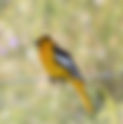
- Bullok's Oriole
Bullok's Oriole Blackbirds, Orioles, and Meadowlarks Bullok's Oriole Icterus bullockii Summer Blackbirds, Orioles, and Meadowlarks Daniel Fitzgerald Found in open or dispersed woodlands, including riparian areas. Note male's black crown, throat, and eye-line, which contrast with orange face; broad white wing patch. Female's yellow colors are most apparent on head, upper breast, and undertail coverts; note pale gray back dull white or grayish-white belly and flanks. Nest is a pendulous-shaped structure built in trees from plant fibers and bark. Diet consists mostly of insects and spiders; also nectar and fruit.
- Peregrine Falcon
Peregrine Falcon Diurnal Birds of Prey Peregrine Falcon Falco peregrinus All Year Diurnal Birds of Prey Wallace DeYoung With its wide dark moustache, slate colored back and light-colored barred breast, the adult is distinctive. Immatures still show a dark moustache but are brown and heavily streaked. Read more
- White Stem Filaree, Musky Storksbill Erodium moschatum
Wildflower Mount Diablo White Stem Filaree, Musky Storksbill Invasive Scientific Name: Erodium moschatum Family: Geraniaceae (Geranium Family) Blooms: Mar - Jun Color: Red-Pink Annual herb Introduced Jump to Blooming Now Blue / Purple Red / Pink White Yellow / Orange Invasive Plants Mike Woodring
- Sachem
Sachem Atalopedes campestris Hesperiidae Skippers Flies March to November Host Plant Grass Nectar Plant Bull thistle Kevin Hinsta Female Hank Fabian Underwing
- Pacific-slope Flycatcher
Pacific-slope Flycatcher Flycatchers Pacific-slope Flycatcher Empidonax difficilis Summer Flycatchers Daniel Fitzgerald Breeds in coniferous and pine oak forests; also frequents woodlands with dense second-growth habitat; usually near water. Entire lower mandible bright orange; also note bold white eye ring with tear-drop shape at rear of eye. Call note, ‘Sue-weet!’ Is frequently given on breeding grounds and easily recognized. Nest in a variety of situations, where it builds a cup-shaped structure from mosses, small roots, grasses, and other vegetation. Diet includes insects and spiders.
- California Honeysuckle Lonicera hispidula
Wildflower Mount Diablo California Honeysuckle Scientific Name: Lonicera hispidula Family: Caprifoliaceae Blooms: May - Jun Color: Red-Pink Vine or Shrub Native Jump to Blooming Now Blue / Purple Red / Pink White Yellow / Orange Invasive Plants Mike Woodring
- Kellogg's Yampah Perideridia kelloggii
Wildflower Mount Diablo Kellogg's Yampah Scientific Name: Perideridia kelloggii Family: Apiaceae (Parsley-Carrot Family) Blooms: Jun-Aug Color: White Perennial herb Native Jump to Blooming Now Blue / Purple Red / Pink White Yellow / Orange Invasive Plants Daniel Fitzgerald
- A Beautiful Evening to Remember
A Beautiful Evening to Remember by Michael Marchiano, Naturalist On a Friday in July July 10, 1998 Black Point at Sunset • Ray Mengel As the sun set and a light wind blew through the valley oaks, five of us gathered in the Mitchell Canyon parking lot for a leisurely evening hike. We were greeted by the sounds of field crickets as we crossed the gate. We headed up Mitchell Canyon Road observing and listening to the last birds of the day heading for roosting spots or singing their night-time serenade. An acorn woodpecker was tapping away at the top of one of the “pantry” trees, juncos and a titmouse flitted among the branches of live oaks, blue oaks, and gray pines. Starlings were finishing an insect meal at the top of another snag. A black-headed grosbeak was singing its heart out in one of the oaks, and a turkey vulture soared overhead as many springtime insects buzzed through the air. Most of the spring wildflowers along the trail had disappeared. The wild oat grasses had turned golden in the evening light. The most alluring late spring flowers were the delicate white “lilies” of the wavyleaf soap plant. These appeared to dance on the end of their thread-like stems. In the shaded areas were remnants of elegant clarkia flowers, and Ithuriel’s spear still bloomed among the grasses. What creatures would we see or hear as the sunlight dimmed and the sky darkened? This question would only be answered by what lay ahead of us. As we continued our twilight hike, we turned at the intersection of Mitchell Canyon Road and Black Point Trail and then turned onto Globe Lily Trail. Along the chaparral section of the trail, chemise was in full white bloom, and the pale pink-colored mallow with its light gray-green leaves and stems dotted our way. The trail itself was coming alive with harvester ants, picking up tiny seeds and carrying them into their underground burrows. Along the trail, we found numerous tarantula burrows. As we peered into them using our flashlights, we could see the velvety spider sitting at the entrance of its home waiting for that unsuspecting prey to wander by and become an evening meal. We reached Red Road and, in the dim glow of the darkening sky, bats could be seen swooping overhead, soaring and turning and chasing the hundreds of flying moths, mosquitoes, gnats, lacewings, and other airborne arthropods. Many species of bats inhabit the canyons of Mount Diablo, all of them insectivores. In flight, it is all but impossible to tell one species from another, but at least one of the bats was twice the size of the others, and we believed it to be a big brown bat, one of the largest bats in our area. As the night darkened, I took out a small black light flashlight and shined it into a pile of downed tree branches. There scurrying among the debris was a small scorpion, glowing in the ultraviolet rays. Another tiny night hunter was on the prowl. The pathways were also littered with Eleodes beetles, those slow-moving black stink beetles that point their tail ends up in the air whenever they feel threatened. As we left Red Road and returned to Mitchell Canyon Road to head back, we picked up the bight shining eyes of two other night-time wanderers. Although we could not make out the creatures (except for the eyes, and they disappeared into the heavy brush immediately), we believe the first was a coyote and the second a deer. One more time on the way back I took out my black light as we neared a rocky outcrop, and again we were all pleasantly surprised with at least a half-dozen scorpions glowing among the rocks. On our final approach to the visitor center, we had the pleasure of seeing a western toad hop across our path and a large Jerusalem cricket (potato bug) run in circles on the path after we shined our light on it. Many wonderful sights greeted us on this night-time hike, and yet many we expected eluded us. We did not hear the coyotes howl; we did not hear or see an owl; poorwills did not call; glow worms were not seen; and no snakes were slithering about. Chorus frogs were not heard, and no bobcats were seen. Who knows what will await us next time… Only by completing the adventure will we unlock a tiny bit of Mother Nature’s treasures. We hope to see some new adventures on our next night hike! BACK TO LIST